
Set of 3 maps of the Baltic Sea by Nagayev
0 PLN
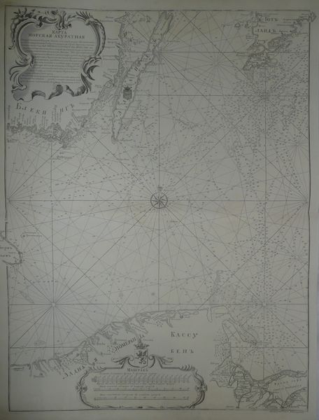
KARTA| MORSKAYA AKURATNAYA| soderzhashchaya vsebe chast baltiskogo morya mezhdu beregami shvets|kimi i pomeranskimi ot goborkha i dantsiga do ostrova borngolma opisana| i vymerena po ykazu EYA IMPERATORSKAGO VELICHESTVA iz'| Admiralteiskoi kollegïi v kotoroj distantsïya mezh' goborkhai gi|lem' na plavanïyakh' leitenanta Viniova 750 goda i proshlikh'| godov' paket' botskikh' a distantsiyazh' i rumby mezhdu| goborkhom' i borngolmom' ot goroda Arkhangelskago| prikhodyashchikh' karablei i paket' botskikh' pla-|vanïyakh' osnovany i glubiny morya mezhdu| temizh' mestami vymereny temizh' opi-|satelmi a chasti beregov' shvetskikh' i pomeran-|skikh' ot goborkha i gilya i ostrovu borngolmu po-|lozhenishvetskikh' kart'.| Razsmotrena vypravlena i vvernoe sostoyanïe privedena| i sochinena na kompas' rumba sklonenïe emyushchej zapa-|dnoe flota kapitanom Alekseem' Nagaevym' 1753.
Below to the right engraver's signature: Grydoroval Georg Unfertsakht
Map of the whole Baltic Sea, comes from uncommon Russian Sea Atlas by Aleksei Nagayev, for the first time published in Petersbourg in 1757(there were several later issues but without changes).
Original map, XVIIIth century,after restoration, barely visible stains, and small tears on margins.
Size 74,5 x 55,7 cm on sheet 83 x 59,8 cm.
Sold as a set of three maps by Nagayev.