
Set of 3 maps of the Baltic Sea by Nagayev
0 PLN
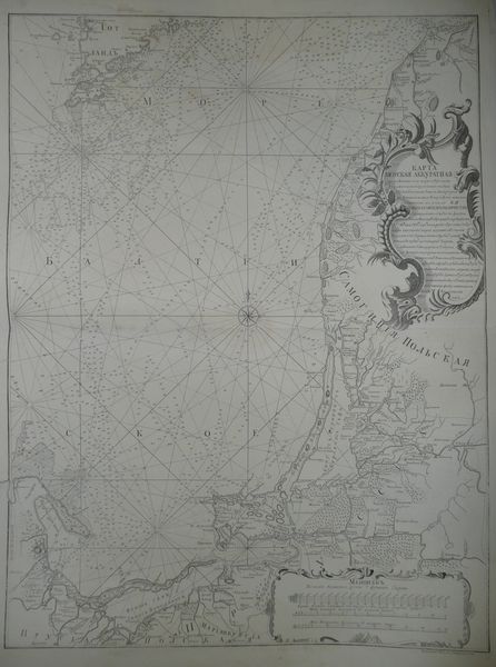
KARTA| MORSKAYA AKKURATNAYA| chast baltiskago morya _beregami| kurlyandskimi i pruskimi ischastiyu| ostrova gotlanda ot mysa lyuzerorta| do Dantsiga i mysa Rezergofta, opisana| i vymerena po ukazu EYA| IMPERATORSKAGO VELICHESTVA| v admiralteisko_ kollegïi flota leitenantami Viniovym i _ushshchinym i prochimi v'| 749m. 1750m. iv' 751m gode khpolozhenïe beregov' s situ-|atsïeyu vneseno vse karte, kurlyanskikh s novoj| Kurlyanskoj barnvkelevo_a Pruskikh snovykh| shvetskikh i protchikh dostovernykh kart'| a distantsïi ot Lyuzerorta i Goborkha| do Dantsiga polozheny isplavanïei'| pom_nutykh Viniova i Pushchina i prot-|chikhpobekamfunym vlutchim shislenïyam pute,| i_oisv___noj ranosti shitiny, mezh'| lyuzerortami dantsigom, rasmotrena| ivypravlena vvnoe sotoyanïe prvvede|na i sochinena flota kapitanom'| Alexeem Nagaevym | 752 goda.
Below to the right engraver's sugnature: Gridoroval Georg Unfertsakht
Map of the southern part of the Baltic Sea, comes from an uncommon Russian Sea Atlas by Aleksei Nagayev, for the first time published in Petersbourg in 1757(there were several later issues but without changes).
Original map, XVIIIth century,after restoration, barely visible stains, and small tears on margins.
Size 74 x 55,7 cm on sheet 83 x 59,8 cm.
Sold as a set of three maps by Nagayev.